Summer does not officially start until about June 21. We tend to think that summer is from Memorial Day to Labor Day. The mountains do not agree; we hiked in May and June on trails with no snow and trails with feet of snow.
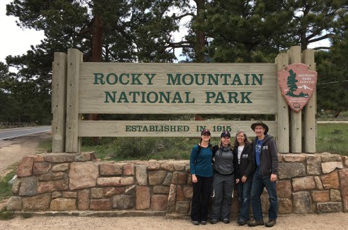
Welcome to Rocky Mountain National Park
Rocky Mountain National Park has been a favorite of mine since I was a small child; we went to the park almost every other year. The park holds several happy memories for me: I proposed to my wife in the park and we honeymooned at the park as well. It is fitting for me that I spent part of May and June in the park for my 60th birthday.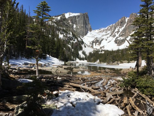
I really enjoyed every hike. The biggest snow hike was our hike from Bear Lake to Lake Haiyaha through the snow.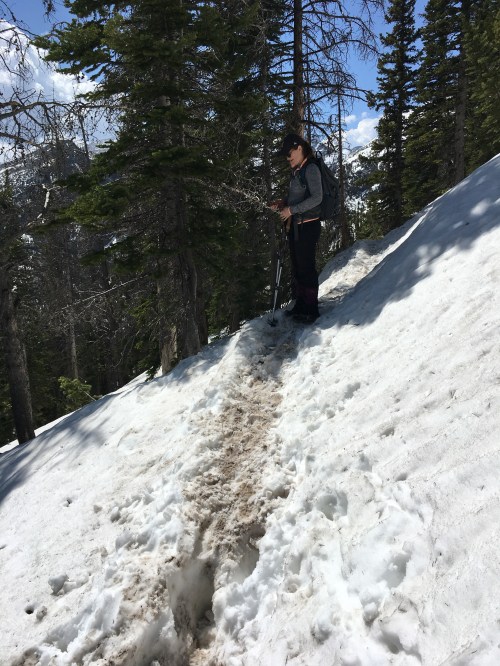
We had a hard time following the path, as the trail was a few feet under the snow.

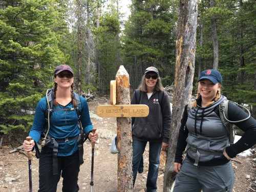
Here is the sign to Lake Haiyaha
As we got closer to the lake, the snow was deeper and we found that boulders were warm and melted the snow. It was hard to avoid stepping through snow up to your hips. Fortunately, on the hike my daughter-in-law had a GPS trail guide that kept us on track when we could not find enough footsteps to go the correct way. Looking back on the hike we were often on the trail and off the trail.
The view from this lake is dominated by (looking at the lake) Otis Peak on the left and Hallett Peak towards the right.


We just called it the hike to lake “H” as we could not pronounce “Haiyaha” which is a Native American word that means “rock” or “lake of many rocks” or “big rocks” depending on the translation.
Not many hikers braved the snow to get to Lake Haiyaha. We did see some people bouldering near the lake. The lake was still mostly frozen and had a really blue hue. On the way up the mountain we were able to get some reception and speak with our son who is currently overseas. It was great to have him see us up on the mountain
We hiked two different ways to see Lake Bierstadt. We enjoyed them both. The hike up from the Bierstadt Lake Trailhead allowed us to enjoy the views of Sprague Lake and Longs Peak on the trail while we steadily climbed more than 600 feet along a series of switchbacks to reach the top of the Bierstadt Moraine. Once we got to the top and under the tree canopy, we saw snow on the path and had snow the rest of the way to the lake. We chose to go straight or around the western edge of the lake both times we hiked. We had to make a path to the lake as we could not see the path.
We had a picnic lunch, flour tortillas with cheese and ham, and more water as we enjoyed the lake sitting on some of the rocks. What a great day watching the beautiful view from the lake. We were able to view Longs Peak, Hallett Peak and Flattop Mountain along with several others.


We also enjoyed hiking to Bierstadt from Bear Lake after taking the shuttle. We encountered a lot of snow at the beginning as we hiked up the Flattop Mountain Trail from Bear Lake. I walked onto Bear Lake, which was a mistake as the ice was not as thick as I thought based on the footprints. My hiking boot went in, but my new merino wool socks dried out fast and I did not get any blisters. It was great hiking with three girls: my wife, daughter and my daughter-in-law. I kept up pretty well! We had another beautiful, clear weather day at Bierstadt Lake. After lunching again and sitting on the rocks, we finished our hike by going back to the Bear Lake shuttle bus station where we were parked.
Other highlights:
We stayed outside of the park in a wonderful cabin on the Big Thompson River. My plan was to eat breakfast outside every morning. The cabin was great with a table on the covered porch just a foot away from the river running swiftly by. I went outside each morning, but one morning it was 25 degrees; this was too cold for me to enjoy breakfast outside, even with the heater on.


The mornings are the best time to hike in the Rockies as the afternoons often bring weather changes and a quick storm. Staying at the cabin allowed us to use the annual park pass with no long lines and “key card” or annual pass card access at the Beaver Meadows entrance.
Part of my morning routine is to watch and be inspired by Darren Hardy. We were listening at the end of May to Darren and he challenged us to walk or run, we chose walk, one mile or more every day. We began that 90 day challenge while we were at the park beginning the first of June. With so many daily hikes to choose from, we had a great start to our challenge.
As our time in the Rockies lengthened, the weather did manage to warm up, even some mornings. Okay, for Colorado, it managed to warm up. Yes, it was cold up in the mountains, but fortunately we could dress for it. Our kids came with what looked like not enough clothing. We had on bulky jackets and sweat shirts, flannel shirts. Apparently science has advanced and our warm weather clothing is much bulkier than what they make today. We will have to look into getting something easier to pack that will keep us just as warm.
Our first experience at Bear Lake was that we could not go too far without our micro spikes. Fortunately we were able to get them a week later when a few kids joined us for my birthday.


We hiked through snow up over my waist in June. It was pretty interesting to see. The park was blanketed in spring snows and it was hanging around. We did not have snow in Estes Park and the area felt like typical springtime weather for the mountains.
A few lessons learned:
Explore more of the area than you have in the past. We went to the Lumpy Ridge and Wild Basin Trailheads this trip. I do not know if I went there as a kid. It is possible, although we camped in Moraine Park campground in the park every year we visited, close to the same camping spot. It was easy enough to get to Bear Lake and the hiking was accessible for a family from there. We really enjoyed how diverse these two areas were from our typical hiking from Bear Lake. We have hiked on the other side of Trail Ridge Road (when it was open in prior visits as an adult) and we did not enjoy those hikes as much as Lumpy Ridge and Wild Basin.


Re-visit your favorite spots. As a kid and an adult I have hiked from Bear Lake many times. It is just a beautiful area. We had a fun time with our birthday visitors hiking some of the trails together.
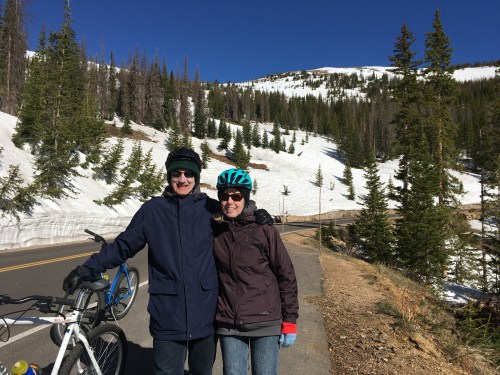
Try something new. We went on a bike ride from Trail Ridge Road. We started at the top from Rainbow Curve as Trail Ridge Road was still closed and we rode down. There was only one small hill, and my riding buddy Mike from Kentucky would have commented that we rode only downhill. It was a fun ride and a really nice way to slow down and take in the mountain grandeur as we peddled by.


We did meet hikers, besides our kids, with all the correct gear. Many believe a cell phone is all that is required, and I saw plenty of people with flip flops and a cell phone. Real hikers know that proper footwear (my boots may be old, but they work well!) make all the difference. A compass, map, water, snacks, sunscreen, a whistle and a camera, okay a phone, are basics. Remember when choosing a hike to look at the distance and the elevation. Even a short hike can be really tough in the mountains.
Take the stops and do not be in a hurry. I decided to allow cars coming behind me to pass as soon as possible. I was not in a hurry. I know, you are saying, ok you are that guy…I wanted to take it all in. Enjoy the day as well as the moment. On one of our car rides, we stopped at Sheep Lake allowing faster cars to pass while we checked out the ranger station near the lake. While there we saw 7 big horn sheep come over to the lake. We also saw elk here and there and, quite frankly, all over the park as well as in Estes Park.


Here is a sample of our hikes:
From Bear Lake:


- Bear Lake to Bierstadt Lake up Flat top Mountain Trail to the Bear Lake bus station where we were parked.
- Bear Lake to Lake Haiyaha by way of Nymph Lake and Dream Lake up the Glacier Gorge Trail. Nymph Lake is a small lake with big views including Long’s Peak. This area was covered with snow and was a place where many would-be day hikers turned around. Dream Lake was worth stopping at and we spent some time here. We did not see many tennis shoe hikers at this stop as the snow was 1-2 feet deep at this juncture. Moving up from Dream Lake is where we encountered the deepest snow and fewer hikers.


Lawn Lake Trailhead—this was one of our first hikes, so we could get acclimated. We did not make it to the lake as we did not have our micro spikes just yet and encountered a lot of snow as we got higher up into the mountains.


We enjoyed the views of the Roaring River From the trailhead. We hiked the Lawn Lake Trail and part of the Ypsilon Lake trail.


Old Fall River Road (closed for cars) from Endovalley picnic area–Old Fall River Road is a historic dirt road built between 1913 and 1920 and does not generally open to cars until July 4. We had a real treat as we got near the road, spotting three big horn sheep grazing near the start of the road. The hike to Chasm Falls took us up roughly 1.4 miles up the old dirt road. Once we found the sign to the falls, we walked the short distance down the paved footpath to the viewing area.


Having a lot of melting snow allowed for a spectacular view of the falls that drop somewhere between 25 and 30 feet. We were happy to have the falls to ourselves as most hikers stopped too soon to get to the falls.


Sprague Lake—we went to this lake after deciding that the trail at Bear Lake was too snowy (we tried and then called for the kids to bring the micro spikes with them for the weekend when they came up). We enjoyed our hike around the lake. It was interesting to see a group of guys standing in the lake fishing. So we guess the lake is not too deep! We hiked over to the Boulder Brook Trail and back to the parking area. As we hiked along the area we came to our first experience with fire rings. We asked some of the passing rangers about this and they shared that the chain saws and big fire rings are part of a prescribed burn program that the park is conducting.


Hike to Cub Lake, the Pool and Fern Lake—The hike to Cub Lake began from the Moraine Park area. We saw a lot of elk grazing near the edge of the meadows. Also, on the way in to park, we saw a moose! Wow.


We were staying on the Big Thompson River and have walked past this river in Estes Park. It was nice to follow the river on the way back from The Pool.


Moraine Park Campground –When my family came to the Rockies we camped here. This is also the place where I proposed to my wonderful wife! We took a hike through the entire area.
With the spring snows, Trail Ridge Road was snowed in. The road was open to (non-motorized) bikers and hikers prior to allowing cars to go up the road.

In the many times I have been to the park, this is the first time I have hiked on Old Fall River Road and Trail Ridge Road. We were impressed with the 30 foot high walls of snow that we passed at even the 2 mile mark up this road. We started our hike from the Rainbow Curve Overlook.


We hiked up until the Ute Trail. It was a brisk 43 degrees when we started and a steep climb up the hill. From the road we had great views and no traffic! We did see some of the snow plow equipment. The trees and animals have all adapted to the snow. We saw many young trees that bent but did not break under feet of snow, sticking out and getting sun. We also saw small wildlife here and birds doing well. The lesson I took from this is that if you want to survive, you can. You can see trees, birds, animals all surviving in extreme conditions, and they do survive, despite the odds.
We took some time to explore the town of Estes Park and we hiked around Lake Estes. It was a good walk and had one major uphill climb. On the hike we encountered a sign describing a potential hazard, an elk calving area, aggressive elk may be present. We did see that elk, no issues for us, thankfully. And, we saw a few other elk on and near the trail around the lake. The town is great fun to explore. We enjoyed eating out and finding a new spot for ice cream.


")

From the Lumpy Ridge Trailhead we hiked up to Gem Lake. This is such a different part of the park. The views may have Long’s Peak, but the red rock is more like the Garden of the Gods.


This was our first park hike without any snow on the path. I do not remember having been to the Lumpy Ridge Trail before and I highly recommend this trail. We did have nice views of the Estes Park valley and some of the surrounding mountain peaks.


Deer Mountain Trailhead starting from Deer Ridge Junction—The summit is 10,013 feet in elevation. Many have recommended this hike as a way to get acclimated to the higher elevations. I enjoyed being able to say we hiked to the summit of a mountain!


One of the guides on the bike ride said we “should summit” and the easiest one in the area was Deer Mountain. We are glad we took this hike up to the top of Deer Mountain. This was a multi-use trail and I am not always a fan of horses on the trail. We encountered a few, and that was okay; we were able to step aside and let them pass us. Outside of the obvious hazard, this trail has some big steps geared for mules or horses and not for humans.
Just like Lumpy Ridge, the Wild Basin, not a far (about 30 minute) drive from the park, is one I do not remember visiting in the past. We took one of our longer hikes here, over 7 ½ miles on the Wild Basin Trail and the North Saint Vrain Fire Trail. This hike featured the lower and upper Copeland Falls, the Calypso Cascades and Ouzel Falls. We found it tough viewing for the Ouzel falls, but worth it.


Once we were past the falls, it became snowy as we headed toward Thunder Lake (up the trail about ½ mile). We turned around—near the twin lakes (which we could not see through the forest) as the snow was too much for us. We went back down the less well-marked path (North Saint Vrain Fire Trail ) with the exciting sign that read “All stock except Llamas prohibited.” We are not sure why or what that would mean. We did not have a llama or any other stock so we took the path. The trail followed the creek or river the whole way back and was generally free from snow.


Adapted from A.A. Milne, “Now we are six” and updated by Retirement travel with Glen
When I was young,
I had just begun.
When I was twenty-five,
I was just married.
When I was thirty,
I was mostly a dad of an expanding family.
When I was forty,
I was not much more.
When I was fifty and still working,
I was just alive and the kids were leaving.
But now I am sixty and retired,
I’m and as clever as clever.
So I think I’ll be sixty now
for ever and ever.
Hiking statistics: 13 hikes and almost 60 miles of trails.
One bike ride—mostly downhill: 20 miles.


Nice posts! Great photos of the Rockies in winter!
LikeLike
Thank you-May and June-still winter this year.
LikeLiked by 1 person
Looks like a wonderful trip with family. I have been to that park many times but your photos are prompting me to go back and see through my “60” year old eyes.
LikeLike